Steps
Table of Contents
Step simulation-area
- Description: The
simulation-areastep creates a polygon of the simulation area in which all trips take place. The polygon is used, for example, to filter out roads outside the simulation area. - Requirements: Optional (default is to not filter by any area).
- Prerequisite: None
- Output file(s): Simulation area
- Estimated running time: A few seconds (except for large OpenStreetMap imports).
There are 4 different ways to generate the polygon, described below.
Method 1: Providing a bounding box
The easiest way to specify the simulation area is to define its bounding box. This however means that the area is limited to rectangles.
The bounding box needs to be specified as the bbox value, which expects a list of coordinates
[minx, miny, maxx, maxy].
By default, the coordinates need to be specified in the simulation CRS.
If you want to specify them in WGS84 (longitude, latitude), you can use bbox_wgs = true.
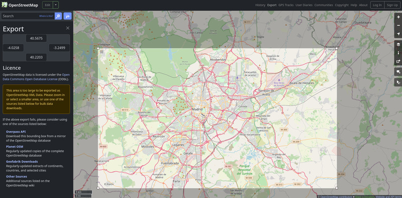
You can go to www.openstreetmap.org to identify the bounding box of a region (as WGS84 coordinates), using the “Export” button.

[simulation_area]
bbox = [1.4777, 48.3955, 3.6200, 49.2032]
bbox_wgs = true
Method 2: Providing a geospatial file with polygon(s)
If you already have a set of polygons which jointly form the entire area (e.g., the administrative boundaries of all municipalities to be considered), you can simply provide as input a geospatial file with those polygons. Then, metropy will read the file and define the polygon of the simulation area as the union of all polygons. If there is a single polygon (e.g., the administrative boundary of the region to be considered), metropy will simply use it as the simulation area polygon.
The file can use any GIS format that can be read by geopandas (e.g., Parquet, Shapefile, GeoJson).
It needs to be specified as the polygon_file value.
[simulation_area]
polygon_file = "path/to/polygon/filename"
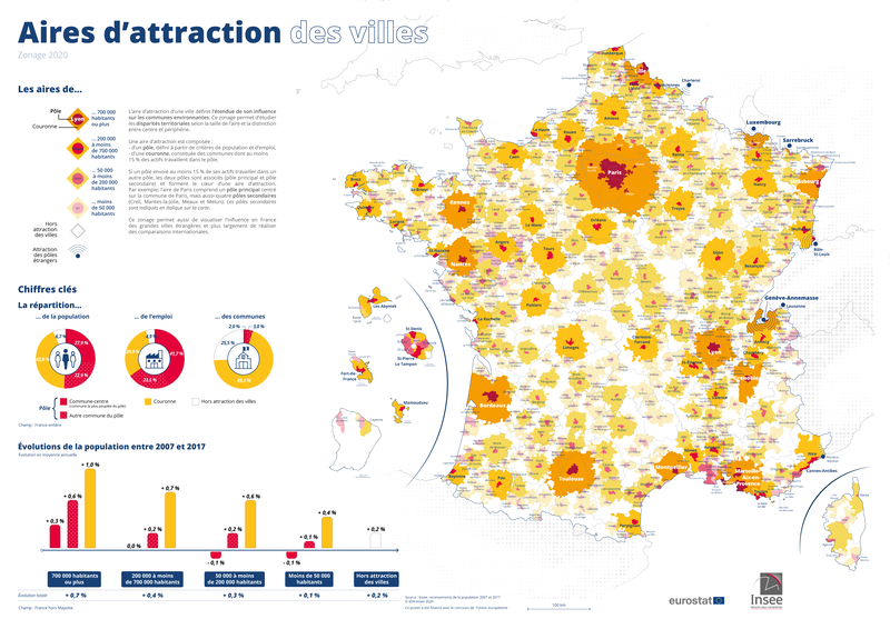
Method 3: Reading a French metropolitan area
A French metropolitan area (aire d’attraction d’une ville) is a type of statistical area defined by the French national statistics office INSEE. It is defined by considering the commuting patterns between cities, making it well adapted to define areas for transport simulations.

The database for these aires d’attraction des villes is publicly available on the
INSEE website.
Metropy can automatically download the database and read the polygon of an area if you set the
aav_name parameter to one of the existing area.
The areas’ name is usually the name of the biggest city in the area.
[simulation_area]
aav_name = "Paris"
If the automatic download does not work, you can download the file locally and tell metropy to use that version:
- Go to the INSEE page of the aires d’attraction des villes database: https://www.insee.fr/fr/information/4803954
- Download the zip file “Fonds de cartes des aires d’attraction des villes 2020 au 1er janvier 2024”
- Unzip the file. You will get two zip files representing shapefiles:
aav2020_2024.zip(polygons of the areas) andcom_aav2020_2024.zip(polygons of the municipalities). Only the former is needed. - In the section
[simulation_area]of the configuration, add the linesaav_filename = "path/to/aav2020_2024.zip"andaav_name = "YOUR_AAV_NAME".
[simulation_area]
aav_name = "Paris"
aav_filename = "path/to/aav2020_2024.zip"
Method 4: Reading OpenStreetMap’s administrative boundaries
Administrative boundaries of various subdivisions are specified directly on OpenStreetMap (e.g.,
states, counties, municipalities), with the tags
admin_level=* and
boundary=administrative.
The OpenStreetMap wiki has a
table
indicating the meaning of each admin_level value by country.
For example, admin_level=6 represents counties in the U.S. and départements in France.
You can use metropy to create the simulation area by reading one or more administrative
boundaries from OpenStreetMap data.
First, you need to set the osm_file value to the path to the OpenStreetMap file.
In the [simulation_area] section, the osm_admin_level value represents the admin_level value
to be used as filter and the osm_name value is a list of the subdivisions names to be selected.
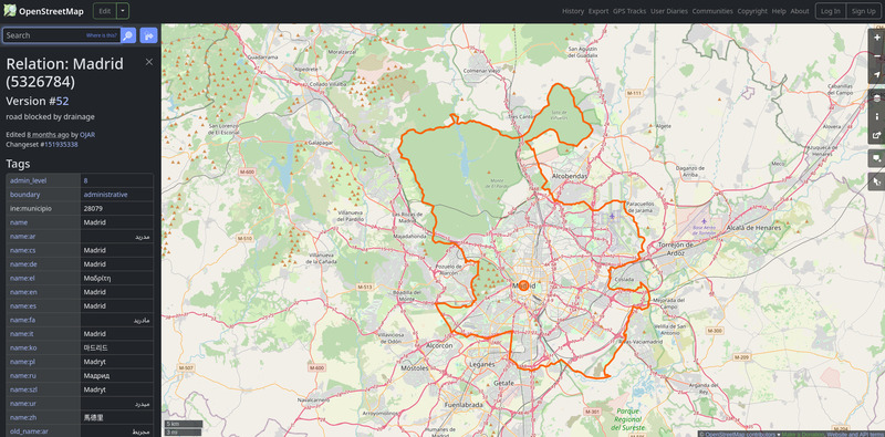
For example, to get the polygon of Madrid, you can use:
osm_file = "path/to/spain.osm.pbf"

[simulation_area]
osm_admin_level = 8
osm_name = ["Madrid"]

Or, to get the polygon of Paris and the surrounding departments, you can use:
osm_file = "path/to/france.osm.pbf"

[simulation_area]
osm_admin_level = 6
osm_name = ["Paris", "Hauts-de-Seine", "Seine-Saint-Denis", "Val-de-Marne"]
Buffering the simulation area’s polygon
Regardless of the method used, the buffer parameter allows you to extend (or shrink) the polygon
of the simulation area by a given amount, expressed in the unit measure of the CRS (usually meters).
Use positive values to extend the area, and negative values to shrink it.
[simulation_area]
polygon_file = "path/to/polygon/filename"
buffer = 500
Step osm-road-import
- Description: Extract the road network, as a graph of directed edges, from OpenStreetMap data.
- Requirements: Required.
- Prerequisite:
simulation-area(optional) - Output file(s): Raw edges, Urban areas (if
urban_landuseis set) - Estimated running time: TODO
# Example configuration.
[osm_road_import]
highways = [
  "motorway",
  "motorway_link",
  "trunk",
  "trunk_link",
  "primary",
  "primary_link",
  "secondary",
  "secondary_link",
  "tertiary",
  "tertiary_link",
  "living_street",
  "unclassified",
  "residential",
]
urban_landuse = [
  "commercial",
  "construction",
  "education",
  "industrial",
  "residential",
  "retail",
]
urban_buffer = 50
With this step, metropy will read the OpenStreetMap data from osm_file and will select all the
ways which satisfy all the following criteria:
- The way has a
highwaytag whose value is in thehighwaysconfiguration parameter. - The way does not have a
accesstag or theaccessvalue is equal toyes,permissiveordestination. - The way’s geometry intersects with the simulation area polygon (if any).
For each valid way, metropy will read the following tags (when they are specified): name (or
addr:street, or ref as fallback), toll, junction (to detect roundabouts), oneway,
maxspeed (or maxspeed:forward and maxspeed:backward), lanes (or lanes:forward and
lanes:backward).
In addition, metropy will flag the ways with traffic signals, give-way signs and stop signs by
reading the highway tag of the ways’ nodes.
From the extracted ways and their data, metropy will then create the edges of the road network graph with the following operations:
- Bidirectional ways (
oneway=no) are split in two directed edges. - Ways are divided in multiple edges when a node of the way that is neither the first nor the last node is an intersection (i.e., another way is intersecting the middle of this way).
Urban areas
If the urban_landuse configuration parameter is defined, then
metropy will also read all the areas from the OpenStreetMap data to retrieve those matching the
following criteria.
- The area has a
landusetag whose value in in theurban_landusevalues, - The area’s geometry intersects the simulation area polygon (if any).
The geometries of the valid areas will then be buffered based on the urban_buffer configuration
parameter and the edges whose geometry is fully contains within urban areas will be flagged as
urban.
The urban areas are saved to the Urban areas file.
Additional output
Metropy will output some statistics regarding the operations performed in the file
osm-road-import/output.txt and it will generate some graphs in the directory
graphs/osm-road-import/.